
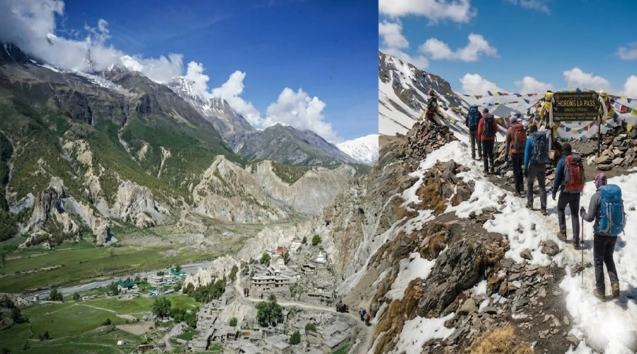
The high-altitude crossing of Thorong La Pass is a dream of every mountaineer, trekker and traveler in the world of mountain travel. Resting at windy crossroad of 5,416 metres from sea level, it's the literal high point of the Annapurna Circuit trek for trekkers. Every year, tens of thousands of trekkers from across the globe set out towards the high-pass from the village of Manang on the east side to descend below to mesmerizing Muktinath on the western side. Thorong La’s crossing is a windswept saddle which offers views starting from the Annapurna massif to the distant ridges of the Mustang’s Himalayan plateau. If you are planning the Annapurna Circuit trek, knowing more about the Thorong La Pass crossing in full detail is very essential for a safe and successful journey.
Thorong La Pass Quick Overview
|
Detail |
Information |
|---|---|
|
Altitude |
5,416 metres above sea level. |
|
Trekking route |
Annapurna Circuit (east to west). |
|
Approach village |
Thorong High Camp (4,925m) or Manang (3,519m). |
|
Descent to |
Muktinath (3,710m). |
|
Elevation gain on crossing day |
Approx. 491 metres (from High Camp). |
|
Distance on crossing day |
Approx. 9 km (High Camp to Muktinath). |
|
Best months to cross |
March to May and September to November. |
|
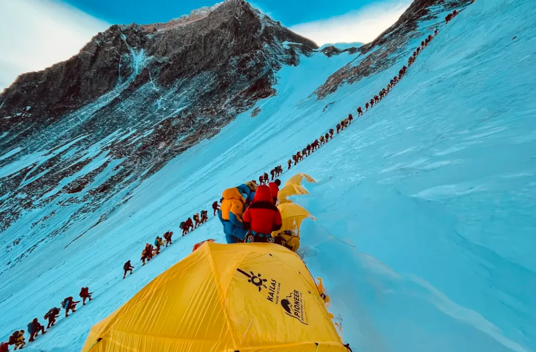
Trekkers crossing annually |
Approximately 50,000 to 70,000 per year. |
Where Is Thorong La Pass and Why Does It Matter for Annapurna Circuit Trek
Thorong La Pass rests quaintly on the main hill ridge dividing the Marsyangdi River watershed on the east to the Kali Gandaki valley lying in the west. The Annapurna Circuit trekkers use this pass as the central geographical pivot or landmark during trekking journeys. The pass is very important as this crossing is the starting point of transition of the Himalayan Landscape from the lush and green monsoon-influenced landscape to the high-altitude Himalayan desert in the Manang district to the dry. Completing the Thorong La crossing is the main or key defining physical and emotional moment of the entire circuit for trekkers choosing this trail. Equally important and breathtaking is the descent into Muktinath which is a sacred site of pilgrimage for both Hindus and Buddhists of the south Asian region.
How Difficult Is the Thorong La Pass Crossing?
The Thorong La Pass crossing on a trekking scale of difficulty is rated as moderately difficult due to the altitude. The rugged trail does not involve technical climbing, fixed ropes scaling , or glacier geography which requires crampons but the steep section and thin pass makes it moderately difficult. It is a walking trail from start to finish mostly with a minor steepness. What makes it demanding is the relentless elevation with the thin level of oxygen as it lies over 5,000 metres. While it's considered moderate fit, beginners and mid-level trekkers cover it in a single long day. However, if you are a person with respiratory conditions and elderly in age the 4,500 metres final push to the pass can be mildly difficult. For, someone who has acclimatised carefully and is physically fit will find it challenging but easily achieve the ascent.
The critical body ailment of condition to watch out for is altitude sickness or AMS. At 5,416 metres, you are receiving only 54 percent of the oxygen available at sea level leading to altitude sickness. The common symptoms of the condition generally include headache, nausea, dizziness, and fatigue. Descending is always the correct response you should take to avoid serious symptoms, and Muktinath sits 1,706 metres lower than the pass which means a quick descent can counteract the altitude problems in an instant. Your pace on summit day matters enormously and you are advised to move steadily and slowly, breathe deeply, and drink water constantly to avoid the condition.
The Trail Route: From Manang to Muktinath via Thorong La
Most trekkers spend two nights in Manang at 3,519 metres to acclimatise before attempting the high pass. On the day before the crossing, you’ll move up to Thorong High Camp at 4,925 metres, a small settlement of teahouses sitting on a cold and windswept hillside above the forest lands below. The High Camp at pass location is basic but comfortable. Sleeping at the high mountain elevation of 4,925 metres gives your body proper time to adjust before the final push. Additionally, the stay here also reduces the total elevation gain on crossing day to a miniscule 491 metres.
You should aim to leave Thorong High Camp between 4 am and 5 am on summit day. The early start of this trek is not optional because the winds in the day are very strong. Thorong La Pass generates powerful afternoon winds almost every day of the year, and crossing the exposed ledges when those winds are fully developed is very dangerous. Hence, you’ll have to climb early in the morning to cross the pass safely in the calm climate. By leaving before dawn, you reach the summit by mid-morning and complete most of your descent before the afternoon winds intensify.
Thorong La Pass Crossing Day Timeline
|
Time |
Waypoint |
Elevation |
|---|---|---|
|
4:00 to 5:00 am |
Depart Thorong High Camp |
4,925m |
|
5:30 to 6:00 am |
First switchbacks in darkness |
Approx. 5,100m |
|
7:00 to 8:00 am |
Sunrise views over Manang valley |
Approx. 5,200m |
|
8:30 to 9:30 am |
Reach Thorong La Pass summit |
5,416m |
|
9:30 to 10:00 am |
Rest, photos, prayer flags |
5,416m |
|
11:30 to 12:30 pm |
Arrival at Charabu tea stall |
Approx. 4,800m |
|
1:00 to 2:00 pm |
Arrival in Muktinath village |
3,710m |
Acclimatization for Thorong La Pass: The Key to a Safe Crossing
The single most important factor in a successful Thorong La Pass crossing is your acclimatization process in the days before the attempt. The Annapurna Circuit's eastern approach through the Marsyangdi valley gains altitude gradually enough to allow natural acclimatization if you follow the recommended itinerary. The two nights in Manang are your most critical rest period. During those days, you should take the acclimatization hike up to the Ice Lake at 4,600 metres or the high viewpoint above Manang to push your body to 4,500 metres and then return to sleep at 3,519 metres. This classic high-sleep-low cycle is what prepares your blood and lungs for the demands of summit day.
Signs that your acclimatization is going well include a resting heart rate that is settling down toward your normal range, no persistent headache in the mornings, and normal sleep with only moderate disturbance from the altitude. If you are still experiencing strong headaches after two nights in Manang, you should not attempt the pass. An extra acclimatization day in Manang costs you 24 hours on your itinerary. A failed or dangerous pass crossing can cost you far more.
Best Time to Cross Thorong La Pass
Spring and autumn offer the best and safest windows for crossing Thorong La Pass. The conditions you will encounter vary dramatically across the four seasons, and your season choice has a direct impact on safety, trail conditions, and the overall experience of your Annapurna Circuit trek.
|
Season |
Months |
Conditions |
Recommended |
|---|---|---|---|
|
Spring |
March to May |
Stable, clear mornings, warming temperatures, moderate crowds |
Yes |
|
Monsoon |
June to August |
Heavy rain on approach, pass itself drier, trail challenging |
For experienced only |
|
Autumn |
Sept to Nov |
Crystal clear skies, firm trail, busiest season, best views |
Yes, best choice |
|
Winter |
Dec to February |
Snow on pass, possible closure, very cold, minimal crowds |
Experienced only |
Permits Required for the Annapurna Circuit
-
Before you set foot on the Annapurna Circuit trek, you need two permits that must be obtained in Kathmandu or Pokhara before the trailhead.
-
Annapurna Conservation Area Permit (ACAP) at NPR 3,000 for foreign nationals, issued by the Nepal Tourism Board
-
TIMS card (Trekkers Information Management System) at NPR 2,000 for individual trekkers or NPR 1,000 for those trekking with a registered agency
-
No additional permit is required specifically for Thorong La Pass itself beyond the ACAP
Essential Tips for Crossing Thorong La Pass Safely
You are responsible for your own safety on the pass, and the tips below come from decades of combined experience on the Annapurna Circuit. Following them carefully will significantly improve your experience.
-
Start no later than 5 am from Thorong High Camp to beat the afternoon winds at the summit
-
Drink a minimum of three to four litres of water on crossing day, even if you do not feel thirsty
-
Carry Diamox if your doctor has recommended it and follow the prescribed dose starting two days before the crossing
-
Wear all your layers when you start in the dark since the early morning temperature at High Camp regularly falls below minus 10 degrees Celsius
-
Never attempt the crossing if you have symptoms of acute mountain sickness including persistent headache, nausea, or confusion
-
Hire a licensed guide if this is your first time at altitude above 5,000 metres since their judgment can be lifesaving
-
Carry a full day of snacks and emergency supplies since the tea stalls between High Camp and Muktinath can be closed in poor weather
What Awaits You at Muktinath After the Crossing
Muktinath at 3,710 metres is one of the most sacred pilgrimage sites in the Himalayan world, visited by both Hindu and Buddhist pilgrims from across the subcontinent. The Muktinath Temple contains 108 water spouts, and the site holds a natural flame fed by underground natural gas that pilgrims believe burns eternally. After the physical intensity of crossing Thorong La Pass, arriving in Muktinath is a genuinely moving experience. The lower altitude brings immediate relief to your breathing, and the warmth of the Mustang plateau sun after the cold of the pass feels extraordinary. From Muktinath, most trekkers continue down the dramatic Kali Gandaki gorge toward Jomsom, home to the deepest river gorge on earth.
If you find yourself intrigued by this blog, join our expert team of guides from Mountain Delight headed towards Thorong La Pass this spring or Autumn trekking season 2026 in Nepal.


.webp)